Bencik Koyu
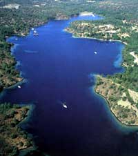 Bencik Koyu is
a bay possessing extraordinary beauty. it extends inland up to 1.5 nautical
miles through Bencik Koyu with its serrated rocks resembling human teeth. Bencik.
which is the narrowest spot on Datça Peninsula, divides the Marmaris and Datça
districts from each other. The inner reachs of the fjord are shallow and marshy,
whereas its other parts are clean and sparkling blue. There is no shortage of
spots for several yachts to moor in this fjord, whereby you can tie a mooring
line around one of the trees that surround the E and W sides of the bay, and
take in all the pleasure this spot has to offer. One of the best places to
anchor is N of the meteorology station towards the end of the fjord whereas at
10-12 m. deep, you’ll need to throw out a mooring line in a NW direction. The
draft at the jetty in front of the solar energy research facility is only one
meter, whereas the draft at the other jetty reaches two m. The other anchorage
is SW of the jetty. Here, you can drop anchor in a seafloor of mud to a depth of
14 m. in a NW direction and tie a mooring line to the shore in a SE direction.
Bencik Koyu is
a bay possessing extraordinary beauty. it extends inland up to 1.5 nautical
miles through Bencik Koyu with its serrated rocks resembling human teeth. Bencik.
which is the narrowest spot on Datça Peninsula, divides the Marmaris and Datça
districts from each other. The inner reachs of the fjord are shallow and marshy,
whereas its other parts are clean and sparkling blue. There is no shortage of
spots for several yachts to moor in this fjord, whereby you can tie a mooring
line around one of the trees that surround the E and W sides of the bay, and
take in all the pleasure this spot has to offer. One of the best places to
anchor is N of the meteorology station towards the end of the fjord whereas at
10-12 m. deep, you’ll need to throw out a mooring line in a NW direction. The
draft at the jetty in front of the solar energy research facility is only one
meter, whereas the draft at the other jetty reaches two m. The other anchorage
is SW of the jetty. Here, you can drop anchor in a seafloor of mud to a depth of
14 m. in a NW direction and tie a mooring line to the shore in a SE direction.
There are several more small coves to anchor in this fjord. Bencik Koyu is
closed off from winds blowing in any direction. Daily winds blow through the
length of the fjord in nice summer weather, whereas these winds gusting back
towards the NW can constitute strong sheer winds in the form of a meltem.
If you are sailing a W course from Datça, you can enter the bay from either
side of the island of Dislice. However, we advise you to enter the bay without
approaching too close to shore while manuevering between the island and the
mainland. If you are sailing from the E. you need to keep a sharp lookout for
the shoals 0.6 nautical miles SE of the island of Dislice. as they lie in only
1.5 m. of water. There is a clean entrance through Bencik Koyu, and there are no
shoals once you sail into the bay.
Adjacent to the Mining Study and Research Facility building, Bencik Koyu,
which is connected to Marmaris via highway, constitutes the narrowest spot of
the peninsula with Gökçeler Koyu on the opposite side, as we had previously
mentioned in an earlier chapter.
In order to protect themselves against the Persian invasion of 540 B.C.. the
Knidians all merged at this point in an attempt to cut off the peninsula from
the mainland. Now, let’s get the story from Herodotus, who was from Caria.
“This here is an extension of Bybassos Peninsula. Ali of the land of the
Knidians is surrounded by water except a thin isthmus. To the N is the Gulf of
Cerameicos Gulf with Sime and the Rhodes Sea to the 8. When the Persian General
Harpagos descended into Ionia, the Knidians started to dig out this isthmus.
They exerted countless manhours trying to transform their homeland into an
island.
However, an incredible event occurred while they were breaking up rocks; the
laborers gradually became inflicted with open sores ali over their bodies,
especially around their eyes. As a consequence, an ambassador was sent to the
oracle at Delphi, who asked what was going on. The oracle replied, ‘The
situation reguires neither a castle nor a digging out. Even if tie had wanted,
Zeus would have been unable to turn this into an island.”
After departing this splendid bay, you can sail into Inbükü, which is one
of several bays across from Tavsan Adasi that are suitable for dropping anchor.